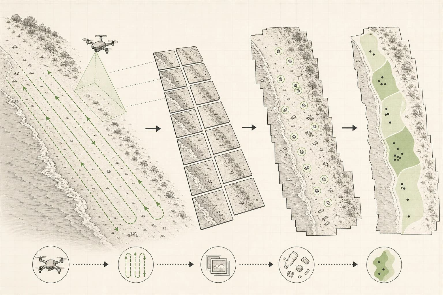
Shoreline survey concept

Shoreline Plastic Map

See where plastic gathers before cleanup time runs out.

Illustrative schematicProposed repeat shoreline survey
Illustrative shoreline survey sequence showing a drone flying parallel routes, image tiles, reviewed debris marks, and a coastal density map.
  1. Flight plan
  2. Repeat route
  3. Image intake
  4. Local review
  5. Shoreline record
A proposed connection between a repeat drone flight, local image review, and a shoreline record. This is not evidence of a completed survey.

After a storm, a cleanup team may have one day and a small volunteer crew. Shoreline Plastic Map would repeat the same locally approved drone route, let people confirm visible debris, and show where cleanup and prevention could have the most effect.

Cleanup teams need a view they can compare

Beach cleanup teams often know which stream floods after rain, which cove collects fishing gear after storms, and which beach is under pressure this month.

A repeatable survey could help them compare that local knowledge across cleanup days and seasons.

  • Which beaches need cleanup this week?
  • Is plastic arriving from land, sea, tourism, fishing, or stormwater?
  • Did last month's cleanup change the pattern or only reset the visible surface?
  • Which habitats are repeatedly exposed?

Repeat the route, review each mark, compare the change

Shoreline Plastic Map proposes a workflow combining repeat drone flights, geotagged imagery, possible debris marks, human verification, and simple comparison maps.

Local reviewers would confirm each uncertain mark and improve the process with every survey.

Every flight makes the next decision better

Visible plastic patterns change with wind, tides, runoff, storms, beach use, fishing activity, and cleanup effort.

Repeat maps could help a local team direct volunteers and review barriers, bins, education, infrastructure, or enforcement against observations from the same coast.

Intended use

Practical questions local teams could use it to explore

Each example begins with a field need that local teams would need to shape, test, and review before any wider use.

  1. Weekly beach maps

    Fly the same beaches on a weekly rhythm so cleanup teams know where visible plastic is building up.

    Intended record: Plastic density maps for priority shorelines and surface-water edges.

  2. Storm response

    Run rapid flights after storms, floods, or heavy runoff to see where debris arrives and where it accumulates.

    Intended record: Post-storm assessment maps that help teams act before debris spreads.

  3. Source tracing

    Compare plastic patterns around rivers, drains, marinas, resorts, fishing sites, and landing areas.

    Intended record: Local leakage maps that support education, infrastructure, and enforcement work.

  4. Intervention review

    Capture comparable flights before and after cleanup operations, barriers, bins, or local policy changes.

    Intended record: Impact reports showing whether an intervention changed the visible pattern.

Concept operating flowHow a shoreline survey could work
  1. Agree the survey area
  2. Fly the repeat route
  3. Review possible debris
  4. Record confirmed findings
  5. Plan and compare action
A proposed sequence for collecting and checking shoreline observations. Local teams would define the route, review rules, and action thresholds.

Proposed system

Designed to be understood, maintained, and adapted

  • Survey planning

    Locally approved route templates and field checks for beaches, waterlines, estuaries, harbours, and post-storm review.

  • Repeat flights

    Support for suitable locally available drones, with tide, light, wind, access, safety, and flight conditions recorded.

  • Image intake

    A field intake workflow for organizing imagery, mission notes, flight context, and review status.

  • Local review

    Possible bottles, bags, foam, ropes, nets, containers, and mixed debris stay provisional until a local reviewer confirms them.

  • Maps and comparisons

    Maps, counts, and repeat comparisons shown alongside tide, weather, rainfall, and river context where locally available.

Useful records

Intended to leave a clear record for local decisions

If field trials support the approach, Shoreline Plastic Map would help teams review observations, decisions, and changes over time in one place.

  • Geotagged shoreline imagery with the flight conditions and local notes needed for a fair comparison.
  • Human-confirmed debris marks and counts by place, survey, and locally useful category.
  • Cleanup maps and repeat comparisons showing where visible patterns changed after action or weather.
Concept review viewPossible local survey record
  1. Confirmed debris
  2. Review notes
  3. Cleanup areas
  4. Repeat comparisons
  5. Action record
A proposed comparison view for confirmed observations, cleanup areas, and change over time. It contains no survey data or measured result.

Safeguards

Local control must shape every field trial

A responsible trial would define who controls the work, what is safe to collect, and how the system can be maintained or stopped locally.

  • Confirm local flight permissions, safety, privacy, and access before setting a route.
  • Keep repeat routes, field conditions, review notes, and local terms visible to the team.
  • Require people to confirm uncertain detections before they become a count or public claim.
  • Support low-connectivity review and practical exports for local field coordination.
  • Keep maps, imagery, source questions, and intervention decisions under agreed local control.

What support makes possible

What funding covers

Support funds the practical work needed to move from a useful idea to one responsible, locally reviewed field trial.

  • Cleanup partner time to choose one shoreline, define the local decision, and review every confirmed finding.
  • Flight permissions, safety and privacy checks, and clear survey rules for tide, weather, light, and access.
  • Repeat-flight preparation, image intake, human-review tools, and a practical comparison map for the pilot area.
  • Field training, low-connectivity working notes, repeat-route documentation, maintenance, and local handoff.

What comes next

Field partners and funders can shape a responsible first trial

The next step is a bounded field question, clear safeguards, and a local team with the time and authority to review the work.

  • Cleanup teams and local stewards

    Choose the shoreline, confirm what counts as useful evidence, review possible debris, and decide how the map should guide cleanup or prevention.

  • Drone pilots and field operators

    Set safe, permitted repeat routes and record tide, light, weather, access, and image quality so comparisons remain honest.

  • Researchers and technical builders

    Help turn confirmed imagery into comparable local evidence, improve review tools, and test whether the approach supports credible source and intervention questions.

Next step

Fund a shoreline map local teams can use

Funding would cover local permissions, route planning, field training, repeat flights, review tools, and a clear before-and-after report. The first pilot would focus on one manageable shoreline and publish what the team could confirm, use, and repeat.